Clear, 83° F
Giant plumes of smoke rose from the Elk Fire on the east side of the Bighorn Range on Friday and were visible more than 100 miles away, including to those attending homecoming at Powell High …
This item is available in full to subscribers.
The Powell Tribune has expanded its online content. To continue reading, you will need to either log in to your subscriber account, or purchase a subscription.
If you are a current print subscriber, you can set up a free web account by clicking here.
If you already have a web account, but need to reset it, you can do so by clicking here.
If you would like to purchase a subscription click here.
Please log in to continue |
|
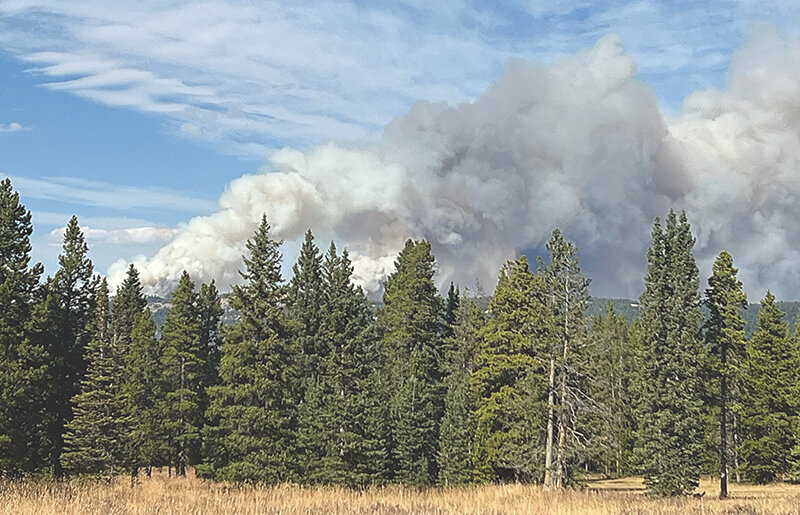
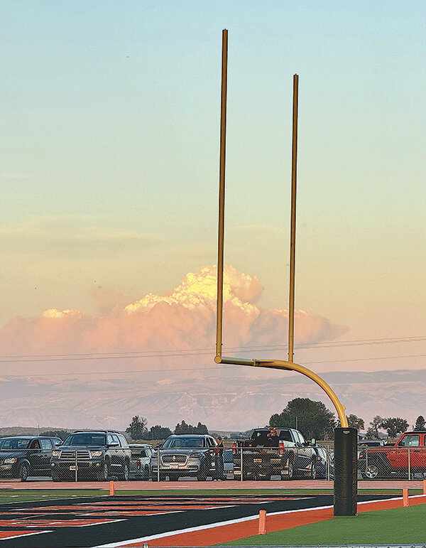
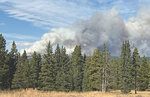

Giant plumes of smoke rose from the Elk Fire on the east side of the Bighorn Range on Friday and were visible more than 100 miles away, including to those attending homecoming at Powell High School’s Panther Stadium. Conditions in the Bighorns were as bad as they looked.
That night there were wind gusts exceeding 50 mph in the Bighorns, pushing fire crews on scene to attempt to save homes, cabins and the Dayton and Sheridan water systems. It put crews on the defensive, said Bighorn National Forest Supervisor Andrew Johnson.
“We are seeing unprecedented weather conditions for this time of year and unprecedented fire behavior,” Johnson said Sunday at a community meeting for those in the path of the fire. “In the last 100 years, the largest wildfire we’d had on the forest was roughly 18,000 acres. That fire took about a month to grow to 18,000 acres. But on Friday night, this fire grew 25,000 acres in a matter of hours.”
Johnson said fire crews have been on the defense from the start. The fire has shown an incredible resistance to control and has been driven hard by the weather, growing quickly.
“I’m sick of being on defense, and so working together with the team, we’re coming up with strategies that we think will have a high probability of success, that mitigate risk to our firefighters and aviators and protect those critical values at risk — your homes, your lives, your livelihoods, your private lands, our backyard and our drinking water. So we’re ready to go on the offense,” Johnson said.
A Red Flag Warning had been issued by the National Weather Service for last Friday and Saturday due to forecasted temperatures in the upper 70s to low 80s and low relative humidity. Winds swept through the incident area, gusting up to 30 miles per hour through the day and 50 mph in the evening, as the fire grew to nearly 73,000 acres. Unfortunately, there is very little chance the areas will see precipitation in the coming week, according to Rocky Mountain Team Meteorologist Shawn Palmquist.
Dayton Mayor Clifford Reed credited fire crews, law enforcement and water treatment plant employees for saving the town’s water facilities.
“It [the fire] did get within a few 100 yards of our water plant,” Reed said. “It is vital to the town of Dayton that our water plant is up and functioning.”
Yet, the erratic fire forced officials to evacuate an area subdivision, and at least two homes burned Friday night and early Saturday morning. Sheridan County Emergency Manager Jesse Ludikhuize said there are thousands of structures in one of three evacuation preparation statuses; 5,000 alone in the current fire zone.
“We’ve offered the fairgrounds for sheltering for individuals that may need that. Luckily, we haven’t had a lot of residents coming and staying at the shelter, which has been phenomenal,” he said.
More than 700 cattle were also moved out of the fire zone over the weekend.
The fire is burning in heavy dead and downed timber and the terrain is rough and remote, according to officials, making it challenging for firefighters to get in or out of the incident area. As the fire expanded to the west, firefighters prepped structures at Burgess Junction, including the Bighorn National Forest’s Burgess Junction Visitors Center at the intersection of U.S. Highway 14 and U.S. Highway 14A (about 25 miles from Dayton), a ranger station, visitor accommodations and several campgrounds.
The Bear Lodge Resort at Burgess Junction is closed “indefinitely,” according to an employee at the lodge and roads leading to the popular recreation area are closed to all non-authorized vehicles. The closure order for the area is in place to “protect the safety of firefighters and visitors looking to travel forest roads and trails,” according to the current incident report from a federal interagency all-risk incident information management system.
Rocky Mountain Complex Incident Management Team 3 took command of the Elk Fire on Oct. 1 after the fire was detected on Sept. 27. Air attack and ground crews initially responded, which included retardant and bucket drops from air tankers and a helicopter. Hand crews were on scene with more resources soon arriving, but as of Monday morning there were 680 personnel on the ground to fight the fire, which was only 10% contained.
Yet, there is good news according to Johnson. Smoke is settling over the area from fires further to the west and is expected to continue, and it is likely to decrease fire activity.
“The weather’s gonna be favorable for us for the next couple of days, and we’re gonna try to take advantage of that and gain as much ground as we can,” he said.
On the downside, the heavy smoke may also impact air operations as helicopters need a minimum of 1 mile of visibility to operate on wildland fires.
The burn area starts at the northern boundary of the Medicine Wheel Ranger District and the Tongue Ranger District, running southeast to Forest System Road 26. The incident area follows Forest System Road 26 west to U.S. Highway 14, then turning north following the eastern edge of U.S. Highway 14 to Burgess Junction, to the west following the northern edge of U.S. Highway 14A to the junction of the Tongue Ranger District and the Medicine Wheel Ranger District boundary near Pole Creek and north along the district boundary following it to the mouth of Little Bighorn Canyon.
There was significant growth to the south, near Story and Big Horn, and the Forest Service is attempting to stop the fire from approaching the areas, as well as any growth to the west, Johnson said.
Current Situation
After having previously used a bulldozer to create a fire line, fire crews utilized a drone to implement a successful burnout operation west of a subdivision near Dayton on Saturday. By intentionally placing fire on the ground between the fire line and the main fire, fire managers were able to control the rate at which the vegetation was burned under calmer conditions. This tactic was utilized to lessen the chance of fire advancing upon structures in the future. Overnight, crews continued burning vegetation to increase the distance between structures and the southeast side of the main fire.
On Sunday crews continued preparing structures to be defensible from fire in the Little Horn Canyon. Along the eastern side of the fire, crews will continue to extinguish areas of heat along established fire lines. This same work will be done in the vicinity of Sunday’s burning operation. Around the perimeter of the fire, crews will use a variety of structure preparation techniques, including the removal of vegetation near structures, constructing fire line, and placing hose and sprinklers where possible.
Firefighter and public safety remain the top priority. The tactics used to suppress the fire will be determined by the terrain, fire and weather conditions, and medical response time with a focus on only implementing plans and tactics that have a high probability of success, Johnson said.
The added 10% containment is along the northeast edge of the fire, to the north of Dayton. Efforts on the southern end of the fire are focused on taking actions to get ahead of fire movement and protect communities, as well as municipal watersheds in the Big Goose drainage, that are potentially threatened by the fire.
Until crews can get the blaze under control, everyone in the fire’s path is praying for rain or snow.
“I wish he was telling us that there was some rain or snow that was coming tomorrow or the next day. But unfortunately, that’s not where we’re at,” said Rocky Mountain Area Complex Incident Management Team 3 Commander, Casey Cheesbrough.
U.S. Highway 14 remains closed from Dayton to Burgess Junction and officials hope to keep roadways in the Bighorns open for those evacuating and firefighting crews.
For more information on closures and evacuations: Contact the Sheridan County Sheriff’s Office at 307-672-3455 or Sheridan County Emergency Management at 307-752-2174.


