Clear, 39° F
On Monday, the upper end of the South Fork of the Shoshone began flooding over the road, and county crews had to divert water there to keep the road open in that area, Edwards said.
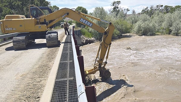
The County Road and Bridge Department is busy working to keep …
This item is available in full to subscribers.
The Powell Tribune has expanded its online content. To continue reading, you will need to either log in to your subscriber account, or purchase a subscription.
If you are a current print subscriber, you can set up a free web account by clicking here.
If you already have a web account, but need to reset it, you can do so by clicking here.
If you would like to purchase a subscription click here.
Please log in to continue |
|
A flood watch is in effect for the North and South Forks of the Shoshone River west of Cody through Sunday, and the Greybull River has spilled over its banks near Meeteetse.
“The rivers are definitely full and raging,” said Park County Engineer Brian Edwards.
On Monday, the upper end of the South Fork of the Shoshone began flooding over the road, and county crews had to divert water there to keep the road open in that area, Edwards said.
The County Road and Bridge Department is busy working to keep bridges free of debris and to shore up bridges by filling in places behind them where material has washed out, he said.
On the South Fork, drainage from Aldrich Creek comes into the river at a sharp angle, aiming into the side of a bridge near the Ishawooa trailhead.
“It keeps cutting farther and farther into the road,” Edwards said. “We have to really watch that one.”
Preventing damage to bridges is the county’s main focus right now in the South Fork and Meeteetse areas, he said.
County crews removed a bunch of debris Tuesday morning that washed up against a bridge on Road 3LE in the Roach Gulch area near Meeteetse. Road 3SL in the same area is under water, but still passable, Edwards said.
“There is a great deal of fallen trees and branches that are being washed down the rivers in the Meeteetse area,” Edwards said. That can begin a buildup of debris and redirect the flow of the floodwater, potentially damaging bridge supports.
“Once water goes behind a bridge, it can wash out pretty fast, so we’re trying to keep that from happening,” he said.
“We’re expecting more problems [Thursday], too,” Edwards said Wednesday. “We just take it day by day and keep an eye on things. Hopefully, we can keep everything shored up.”
With the forecast predicting highs in 90s today (Thursday) and Friday, the National Weather Service issued a flood watch Tuesday for the Shoshone River Basin west of Cody.
“We’re going to be looking at temperatures in the low to mid 90s in the lower elevations; and above 10,000 feet, in the low to mid 70s,” said Tim Troutman, warning coordination meteorologist for the National Weather Service office in Riverton.
Those high temps are 15 to 20 degrees above average for this time of year, Troutman said.
With a foot or more of snow still covering most of the mountains in western Wyoming, “we’re definitely looking at some sharp increases in runoff,” he said. “We’re forecasting minor flooding Friday and Saturday afternoon, and that’s definitely expected to continue as we’re moving up to and including this weekend.”
Gusty winds of 10-20 mph are forecast for today and Friday in advance of a cold front, further accelerating the snowmelt and increasing the potential for flooding, Troutman said.
During high runoff, people should avoid walking or driving through floodwater.
“If you see water getting close to and covering the road, it’s important not to drive through or cross those areas,” he said.
The National Weather Service’s advice is, “Turn around, don’t drown.”
People planning to travel this week should check on the road conditions by calling 511 or visiting www.wyoroad.info, Troutman said.
He said the Snake River basin near Jackson also is under a flood watch, while, in Fremont County, multiple rivers are all approaching or overflowing their banks and could cause problems on highways.
Troutman said a cold front will arrive with the weekend, and it will cool temperatures down to highs in the mid 70s, but with winds of 15-25 mph.
The cooler temperatures “will result in a lessening of the snowmelt as we head into the early part of next week,” he said. “In the higher elevations, the highs will be in the mid to upper 50s, with lows in the 30s at night.”
Then, for the following eight to 12 days, the weather will be slightly cooler than normal, he said.


