Clear, 49° F
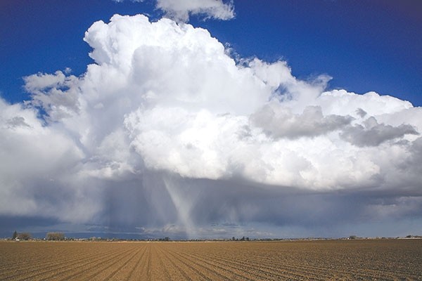
Chris Jones, meteorologist in charge at the National Weather Service Office in Riverton, said Saturday afternoon’s weather was convective, leading to the formation of graupel — moisture that freezes into soft balls.
Graupel forms when “a …
This item is available in full to subscribers.
The Powell Tribune has expanded its online content. To continue reading, you will need to either log in to your subscriber account, or purchase a subscription.
If you are a current print subscriber, you can set up a free web account by clicking here.
If you already have a web account, but need to reset it, you can do so by clicking here.
If you would like to purchase a subscription click here.
Please log in to continue |
|
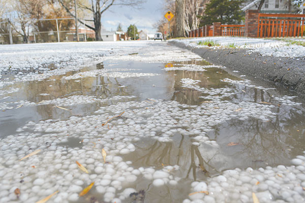
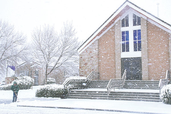


Powell got three-fourths of an inch of precipitation over the weekend. It fell in the form of graupel (little frozen balls of snow) on Saturday afternoon, and heavy, wet snow on Sunday morning.
Chris Jones, meteorologist in charge at the National Weather Service Office in Riverton, said Saturday afternoon’s weather was convective, leading to the formation of graupel — moisture that freezes into soft balls.
Graupel forms when “a lot of little ice droplets” collect and freeze around snowflakes, getting bigger and bigger. When it falls out of the sky, it looks like little snowballs, he said.
“It almost turns into what some people might call an ice pellet; it looks more like a small ball of Styrofoam. It bounces, and it’s light.”
Unlike hail, which forms when a drop of rain freezes and continues to grow as it collects ice crystals, “graupel never melts,” Jones said.
On Sunday morning, cool air aloft combined with an unstable weather pattern to produce heavy, wet snow, Jones said. The snow fell in bands, with some areas seeing more snow than others.
“There were very sharp lines between Cody and Powell,” Jones said early Monday afternoon. While the snow had melted in Powell, “Even now as I look at it on satellite, there is still snow on the ground. ... The McCullough Peaks are still hammered with snow,” he said. “You can see where the highest peaks on the McCullough Peaks are still a brighter white.”
A significant amount of snow fell west of Ralston on Sunday, and “around the Badger Basin Road, it’s still very obvious today where the snow was. It wasn’t mixing [with rain] up there; it was probably snow the whole time.”
Snow was still on the ground at Heart Mountain, but even more fell north of the mountain. Corbett Bridge also had a lot of snowfall, Jones said.
“We saw that same kind of thing around Riverton,” Jones said, with reports of as much as 6 inches of snow in that area.
A location south of Powell reported 0.24 inches of precipitation Saturday, and another 0.51 inches on Sunday, for a total of 0.75 inches.
PowellWeather.net shows a precipitation total of 0.84 inches for April so far. That is more precipitation than fell in the entire month of April during nine of the last 12 years, according to that website’s precipitation records.
Jones said a similar weather pattern is forecast to develop later this week.
“It will be warm Thursday, then you’ll have a windy day on Friday, but you won’t have snow,” he said. “It will be 14-17 degrees cooler in your part of the state, with winds of 15-25 miles per hour, and it won’t feel nearly as warm.”
Saturday’s weather is expected to be cooler as well, but without as much wind, Jones said.


