Mostly Cloudy, 41° F
Tuesday night’s snow was blown around by cold winds, primarily from the north, piling it up in drifts and making it difficult to navigate area roads Wednesday morning.
Despite those challenges, Powell schools opened as usual on Wednesday, with …
This item is available in full to subscribers.
The Powell Tribune has expanded its online content. To continue reading, you will need to either log in to your subscriber account, or purchase a subscription.
If you are a current print subscriber, you can set up a free web account by clicking here.
If you already have a web account, but need to reset it, you can do so by clicking here.
If you would like to purchase a subscription click here.
Please log in to continue |
|
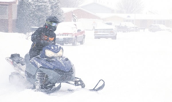
Old Man Winter still has a strong grip on Powell and the surrounding area, evidenced by an estimated 6-7 inches of snow dumped by another blizzard-like storm Tuesday night and Wednesday.
Tuesday night’s snow was blown around by cold winds, primarily from the north, piling it up in drifts and making it difficult to navigate area roads Wednesday morning.
Despite those challenges, Powell schools opened as usual on Wednesday, with all buses running. However, after-school activities that afternoon were canceled to allow children to return home early and safely.
The winter weather was the topic of many a conversation around town as people wondered what had changed in recent weeks to turn a mostly mild fall into a bitterly cold, snowy winter.
The answer is in the wind, according to Meteorologist Chuck Baker of the National Weather Service office in Riverton.
In recent years, the jet stream has run a northerly track across the Pacific Northwest, bringing moisture into Washington state. But it recently shifted farther south into moister air over the northern two-thirds of California, then tracking westward from the San Francisco area toward western Wyoming.
“It’s a pattern we haven’t seen in a while,” Baker said. “In the fall, that jet was way up north in Canada, in Alberta and Saskatchewan.”
The result was major flooding last week in the formerly drought-stricken area of California, then wave after wave of snow hitting western Wyoming beginning over the weekend, he said.
Baker noted that, for several years, the Jackson Hole Ski Area had enough snow to open by Thanksgiving; then, during more recent years, it didn’t.
“They didn’t have enough snow by this Thanksgiving to open, then, about a week and a half later — boom!” Baker said. “The snow with this storm has been incredible.”
The town of Jackson got 30-40 inches of snow — an unusually heavy amount — while one site on the west side of the Tetons was buried by 54 inches of the white stuff. Areas on the western slopes of the Absarokas got between 20-27 inches of snow in a fairly uniform covering, he said.
Once a strong storm like that bumps up against the west side of tall mountains like the Absarokas, it produces a vacuum on the eastern side of the mountains, and snow from the storm and cold air from Canada and Montana can be sucked in together over northern Wyoming. And that’s how the Big Horn Basin ended up with a moist snowstorm accompanied by single-digit temperatures, Baker said.
“You still have this moist air coming over that cold, dense air, and it allows that lift to extend east over the mountains, (as if) the mountains extended much further to the east than they do,” Baker said. “If it sets up just right with those high mountains, the northern Absarokas, you end up with these bands of snow.”
“They don’t usually extend as far south as Meeteetse to Basin; they’re usually north of that,” he added. “That’s what was set up to produce this snow in the Big Horn Basin.”
The snow abated largely in the afternoon, and was expected to exit the area overnight.
“That will just leave the cold in place,” Baker said. “It will get cold tonight (Wednesday), with portions of the Basin probably as low as 15-25 below, and you will have some areas of fog try to develop.”
The eastern side of the Big Horn Basin was expected to experience the lowest temperatures.
Cold high pressure is expected to dominate today (Thursday) and through the weekend, bringing sinking air, clearing skies and lighter winds.
“I think you will see a prolonged period of nicer weather — cold, for sure, but clear, and by the weekend it will be noticeably warmer,” Baker said.
That gradual warming trend will bring westerly winds to the Cody foothills.
“The Clark area will be quite windy,” Baker said.
Another snowstorm is likely to come into western Wyoming Tuesday night and Wednesday, then into the Big Horn Basin on Thursday and Friday, he said.


