Clear, 56° F
The ultimate goal is to create a horse/hiker-only trail from Joseph, Ore. to Chinook, Mont., 40 miles south of the Canadian border, said Julie Molzahn, U.S. National Forest Service Nez Perce National Historic Trail (NPNHT) comprehensive plan …
This item is available in full to subscribers.
The Powell Tribune has expanded its online content. To continue reading, you will need to either log in to your subscriber account, or purchase a subscription.
If you are a current print subscriber, you can set up a free web account by clicking here.
If you already have a web account, but need to reset it, you can do so by clicking here.
If you would like to purchase a subscription click here.
Please log in to continue |
|
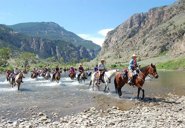
Plans are underway to update and revise the comprehensive plan for the Nez Perce National Historic Trail.
The path, also known as the Nee-Mo-Poo Trail, follows the 1877 flight of the non-treaty Nez Perce Native American tribe from their homelands in Oregon while being pursued by U.S. Army.
The ultimate goal is to create a horse/hiker-only trail from Joseph, Ore. to Chinook, Mont., 40 miles south of the Canadian border, said Julie Molzahn, U.S. National Forest Service Nez Perce National Historic Trail (NPNHT) comprehensive plan revision coordinator, in Cody Sept. 9. A dozen or so members of the public attended the meeting.
Portions of the trail have been used for thousands of years by Native Americans in pursuit of bison and other game, said Sandi McFarland, NPNHT administrator.
In 1986, Congress amended the National Trails System Act of 1968 to include the 1,170-mile Nez Perce trail. The trail includes a designated corridor encompassing 4,161 miles of roads, trails and routes, according to a NPNHT news release.
A 1990 comprehensive plan was developed, but like a forest plan, its duration was not to exceed 15 to 20 years, according to the NPNHT comprehensive plan revision. A draft revision plan will be completed in late 2016, Molzahn said.
At this time only 400 miles of trail — on federal land — is designated for horses or hikers only, McFarland said.
A 1-mile wide corridor is sought from Oregon to Montana, but she realizes they must be flexible, agreeing to much narrower stretches in some areas, Molzahn said. This is especially true near private property where the corridor could end up being only 20 to 40 feet by homes.
There is a need to address recent changes to the NPNHT corridor such as energy development, cell towers, urban interface and new recreation activities not originally addressed in the current plan, the revised plan states.
She realizes oil and gas development is a huge factor in planning, Molzahn said. The goal is to do what is best for the public and local landowners and map the best route.
“This is the time to identify areas with high potential for historical sites and trail segments,” Molzahn said.
The NPNHT personnel want to work with landowners, state, county, federal and highway departments to open the Nez Perce corridor. They realize that some portions of the route must share the trail with wheeled vehicles for now, but the ultimate goal is to designate the entire track from Wallowa Lake to Chinook as horse or foot traffic only, Molzahn said.
Rights of way must be established and the land for the trail could be acquired using a variety of options such as conservation easements. “This is going to take at least five years,” Molzahn said.
They have been approached by ranchers who wish to establish conservation easements to keep their land for future generations. Each agreement will be specific to the needs of that landowner, Molzahn said.
Each summer, since 1965, the Appaloosa Horse Club from Moscow, Idaho, rides around 100 miles of the trail.
Many private landowners allow the riders to cross their land, McFarland said.
The NPNHT is seeking public input through a series of public meetings,” said Roger Peterson, NPNHT public affairs specialist. “The more feedback we receive, the better the final plan will be to help administer this national resource for future generations. If you are unable to physically attend one of the 11 public meetings scheduled during the upcoming month, trail staff will also be hosting a virtual meeting on Sept. 29.”
More information about that meeting can be found on the NPNHT website under the CP Revision section. This is just a draft, McFarland stressed.
“We need comments from the public because this is a national historic trail and we want it to serve the best interests of the public,” Molzahn said.
“Everything is on the NPNHT website,” Molzahn said.
The website is at www.fs.usda.gov/npnht/. Comments can be mailed to Plains/Thompson Fall R.D., PO Box 429, Plains, Mont. 59859.
Plans are underway to create a trail from Joseph, Ore., to Chinook, Mont., to commemorate the 1877 flight of members of the Nez Perce tribe.
Chief Joseph and others led nearly 750 Nez Perce men, women and children and 1,500 horses over 1,170 miles through the mountains, on a trip that lasted from June to October 1877, according to the Nez Perce National Historic Trail (NPNHT) website.
Forced to abandon hopes for a peaceful move to the Lapwai reservation, the Nez Perce chiefs saw flight to Canada as their last hope for peace and a chance to live in their traditional manner.
“Trail of sadness,” was how a Nez Perce National Historic Trail documentary film described the flight.
The flight of the Nez Perce is commemorated at 38 sites in Washington, Oregon, Idaho and Montana as part of the Nez Perce National Historical Park, according to the documentary.
Traditionally, Nez Perce lived in separate bands and were led by warriors. This fluid social and political system allowed them to travel in small groups during times of limited resources (such as winter) and as large groups during times of abundance (such as summer).
But the system confused United States treaty negotiators, who assumed the signature and agreement of one band bound the entire tribe. This confusion helped initiate the troubles of 1877. Several bands never sold their land to the federal government and never agreed to move to a reservation. The most famous leader, Chief Joseph, was one of several who led their people on the journey of 1877.
The tribe’s first contact with explorers Meriwether Lewis and William Clark was friendly. Even when white settlers flocked to their homelands along the Snake River, most of the Nez Perce peacefully moved to a reservation.
However, about a quarter of the Nez Perce refused to accept internment on a reservation. Government pressure to force these last resisters to comply finally led to the outbreak of the Nez Perce War of 1877. A small band of warriors — never more than 145 men, though joined by about 500 noncombatants — fought U.S. soldiers at four major battles.
The third battle of the Nez Perce War occurred in the summer of 1877. Fleeing eastward with hopes of escaping to Canada, the Nez Perce made camp in the Big Hole Basin in present-day western Montana.
At 3:30 a.m., Col. John Gibbon attacked the sleeping Nez Perce with183 men. Raking the Indian lodges with withering rifle fire, it appeared the soldiers were victorious. The Nez Perce, however, soon counterattacked from concealed positions in the surrounding hills.
After four days of sporadic fighting, the Nez Perce withdrew.
The battle dealt the Nez Perce a grave, though not fatal, blow. The remaining Indians were able to escape, and headed northeast to Canada.
Two months later, on Oct. 5, 1877, Col. Nelson Miles decisively defeated the Nez Perce at the Battle of the Bear Paw Mountains. Those who were not killed surrendered and reluctantly agreed to return to the reservation.
The Nez Perce were only 42 miles short of the Canadian border.
“From where the sun now stands I will fight no more forever,” Chief Joseph is credited with having said.


